



The research integrates water quality testing, geoelectrical surveys, and microtremor measurements to map aquifer structures and support sustainable groundwater management.
SEMARANG, INDONESIA: The National Research and Innovation Agency of Indonesia (BRIN) and Universitas Negeri Semarang (UNNES) conducted a collaborative study to identify groundwater potential in Cepoko Subdistrict, Gunungpati District, Semarang, from Sunday to Monday, July 19–20, 2026.
The research focused on aquifer structure modeling through the integration of microtremor and geoelectrical methods. The team also conducted water quality testing to obtain a more comprehensive understanding of groundwater conditions and potential within the study area.
Seven community-owned wells were selected as groundwater sampling points. The collected samples will be analyzed in a laboratory, and the results will be integrated with geophysical data obtained during the field measurements.
A researcher from BRIN’s Research Center for Limnology and Water Resources, Dino Gunawan Pryambodo, M.T., explained that combining water quality and geoelectrical data would help the team understand aquifer conditions more comprehensively.
“The seven groundwater samples collected from community wells will be analyzed in the laboratory. The results will then be integrated with the geoelectrical data collected during the field measurements,” Dino Gunawan Pryambodo said.
Cepoko was selected because the area experiences reduced water discharge during the dry season. This condition makes it a relevant location for studying the presence, depth, and potential of aquifers that may support local water needs.
A researcher from BRIN’s Research Center for Ecology, Joko Prihantono, Ph.D., stated that the study was expected to provide scientific information on groundwater conditions in the area.
The field activities were led by the Coordinator of the Master’s Program in Physics at FMIPA UNNES, Prof. Dr. Supriyadi. Measurements were conducted using a Water Quality Checker to examine several water quality parameters and geoelectrical equipment to estimate subsurface conditions.
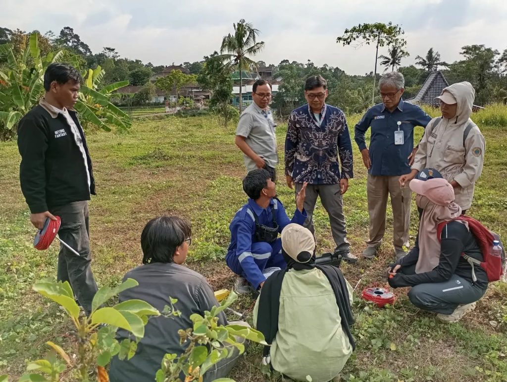
Researchers from BRIN and UNNES discuss field measurements conducted to map aquifer structures and assess groundwater potential in Cepoko.
Through the combined methods, the research team aimed to obtain a clearer picture of aquifer structures, well-water conditions, and groundwater resources that could be managed sustainably.
The research results will be presented to the Cepoko Subdistrict administration as scientific information and recommendations for groundwater management policies, particularly in responding to reduced water availability during the dry season.
In addition to Prof. Dr. Supriyadi, the UNNES research team included Dr. Khumaedi and Dr. Agus Yulianto. Four FMIPA UNNES students also participated in the study: Artikasari, Aristiwati, Annisa, and Yuda.
The students gained direct experience in field data collection, instrument operation, environmental observation, and collaborative research involving a university and a national research institution.
The BRIN and UNNES collaboration supports several Sustainable Development Goals (SDGs), particularly SDG 4: Quality Education, SDG 6: Clean Water and Sanitation, SDG 9: Industry, Innovation and Infrastructure, and SDG 17: Partnerships for the Goals.
The study contributes to SDG 6 by supporting groundwater mapping and sustainable water resource management. The use of scientific and geophysical methods supports SDG 9, while student participation strengthens research-based learning in line with SDG 4.
The partnership between BRIN and UNNES also reflects SDG 17 by connecting a national research institution, a university, students, local government, and the community through collaborative research.
Through this study, BRIN and UNNES are expected to produce data-based recommendations that support accurate, sustainable, and community-oriented groundwater management in Cepoko.